DES MOINES, IOWA — Forecasters are closely watching a developing severe weather setup across western and central Iowa for later this afternoon and evening, with an enhanced tornado threat outlined for a corridor running from the Nebraska border through Storm Lake, Carroll, Ames and toward Des Moines. The environment is expected to turn favorable for rotating thunderstorms as strong wind shear combines with increasing instability, and forecasters say a few tornadoes will be possible if storms can become established and remain discrete as they move from eastern Nebraska into western Iowa.
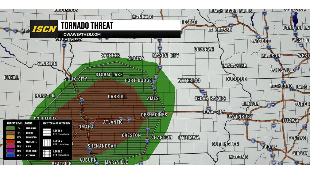
Favorable Wind Shear and Instability Raise Tornado Risk From Eastern Nebraska Into Western Iowa
Meteorologists tracking the setup say the atmosphere later today could turn favorable for rotating thunderstorms, driven by strong wind shear and increasing instabilitybuilding through the afternoon. If storms manage to fire and stay discrete rather than merging together, forecasters say a few tornadoes will be possible as the activity tracks from eastern Nebraska across the state line into western Iowa. The setup mirrors classic supercell ingredients for the region, with the greatest uncertainty tied to how quickly storms organize once they develop.
Storm Lake, Carroll, Ames and Des Moines Sit Inside the Highest-Risk Corridor
A tornado threat graphic issued for the event outlines an outer marginal risk zonestretching from Sioux City and Spencer in the north down through Omaha, Council Bluffs, Shenandoah and Chariton to the south, with an inner, higher-end zone rated for EF2-intensity tornado potential covering Storm Lake, Fort Dodge, Carroll, Ames, Atlanticand Des Moines. That inner corridor represents the area forecasters consider most likely to see organized, rotating storms capable of producing a tornado, while communities in the broader green-shaded zone face a lower but still real threat.
How the Tornado Risk Levels and Max Intensity Scale Break Down
The threat graphic accompanying today’s outlook uses a seven-tier scale ranging from a 2 percent marginal risk up through 5 percent slight, 10 percent enhanced, 15 percent moderate, 30 percent high, 45 percent very high and 60 percent extremerisk categories. Today’s outlook places the corridor from Storm Lake through Ames and Des Moines in the enhanced tier, with the surrounding green-shaded area reflecting the lower, marginal risk. The graphic also breaks down potential tornado intensity on a separate three-level scale, with Level 1 corresponding to EF2 tornadoes, Level 2 to EF3 tornadoesand Level 3 to EF4 tornadoes; today’s setup is being flagged at the Level 1, EF2-intensitytier for the highest-risk corridor.
Forecasters Warn a Sustained Supercell Could Support a Stronger, Long-Track Tornado
There is still real uncertainty built into today’s forecast. Morning storms and lingering cloud cover could limit how much instability builds through the day, and forecasters caution that any storms which do form may quickly merge into clusters or a line rather than staying separate, discrete cells. However, if a sustained, surface-based supercellmanages to develop and hold together, forecasters warn the environment could support a stronger tornado than what a quick-hitting, disorganized storm would produce. That possibility is the primary reason the threat is being flagged well ahead of this afternoon’s storm development.
Large Hail, Damaging Winds and Flash Flooding Threat Accompany the Tornado Risk
Tornadoes are not the only hazard forecasters are highlighting for western and central Iowatoday. Large hail and damaging straight-line winds are also possible with any storms that develop, and forecasters are warning of very heavy rainfall capable of producing a flash flooding threat as storms move across the region. Residents in the outlined corridor are being told to prepare for the full range of severe weather hazards, not just the tornado risk, as the same storms capable of producing rotation are also expected to be efficient rainfall producers given the available moisture and instability in place.
Timing Narrows to First Few Hours After Storms Develop This Afternoon and Evening
Forecasters say the greatest concern for tornado development appears to be during the first few hours after storms initially form later this afternoon and evening, when individual cells are considered most likely to remain discrete before clustering. Once storms merge into clusters or a line, the tornado threat typically decreases even as the damaging wind and heavy rainfall threats can persist or increase. Meteorologists are urging residents across western and central Iowa to have multiple ways to receive warnings today, noting that the forecast team will continue monitoring the latest data and provide updates as the threat evolves through the afternoon and evening hours.


