BALTIMORE, MARYLAND — A soaking week is ahead across the Mid-Atlantic, with rainfall potential through Thursday showing widespread totals of 2 to 3 inches or more, according to a National Blend of Modelsanalysis from Just In Weather. Beyond this week’s rain, the jet stream pattern shifts by next weekend, sending genuinely cooler airinto the Baltimore area, even as a separate NOAA Temperature Outlook shows much of the central US, including Dallas and Houston, staying hot right through the same stretch.
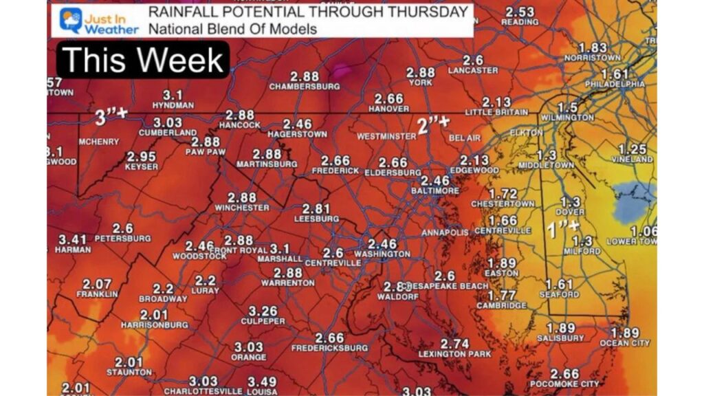
Culpeper, Louisa and the Virginia Piedmont See the Heaviest Rain
If you’re in Culpeper, Virginia, or nearby Louisa and Charlottesville, you’re looking at some of the highest totals on the entire map, with Culpeper forecast for 3.26 inches and Louisa and Charlottesville both topping 3.49 inches. Add in Orange at 3.03 inches, and this stretch of the Virginia Piedmont stands out as one of the wettest corners of the entire region through Thursday.
Cumberland, Hancock and Western Maryland Also Face 3 Inches or More
Farther north, western Maryland and the Panhandle region see similarly heavy totals. Cumberland is forecast for 3.03 inches, with Hyndman, Pennsylvania, just over the border at 3.1 inches and Petersburg, West Virginia, topping the list at 3.41 inches. If you’re anywhere across this mountainous corridor, from Keyser to Hancock, expect this week’s rain to add up quickly given the terrain-enhanced totals showing up on the forecast map.
Baltimore, Annapolis and Washington See a Solid 2.4 to 2.6 Inches
Closer to the coast, Baltimore itself is forecast for 2.46 inches, matching Annapolis and Washington, D.C., at the same total. If you’re commuting or running errands anywhere across the Baltimore-Washington corridorthis week, expect repeated rounds of rain to add up to a genuinely soggy stretch rather than just a passing shower or two.
York, Lancaster and South Central Pennsylvania Stay in the 2.6 to 2.9 Inch Range
Just north of the Maryland line, York is forecast for 2.88 inches, with Lancasterclose behind at 2.6 inches and Hanover at 2.66 inches. If you’re anywhere across South Central Pennsylvania, this week’s rain totals put you right in line with what’s expected across much of northern Maryland, making this a broad, multi-state soaking rather than a localized event.
Philadelphia and the I-95 Corridor See More Moderate 1.5 to 2.5 Inch Totals
Heading toward the coast, Philadelphia is forecast for a more moderate 2.13 inches, while Wilmington, Delaware, comes in lighter at 1.5 inches. If you’re along the I-95 corridorbetween Philadelphia and Wilmington, expect a genuinely wet week, just not quite matching the heavier totals piling up farther west and south across Virginia and western Maryland.
Eastern Shore Communities From Easton to Ocean City See Lighter Rain
Out toward the Eastern Shore, totals ease up considerably. Easton is forecast for 1.89 inches, with Cambridge at 1.77 inches and Ocean City matching Easton at 1.89 inches. If you’re anywhere across the Delmarva Peninsula, expect this week’s rain to be real but noticeably lighter than what’s hitting communities closer to the mountains and Piedmont farther west.
Fredericksburg, Lexington Park and Southern Maryland Round Out the Heavy Zone
South of D.C., Fredericksburg is forecast for 2.66 inches, with Lexington Park, near the mouth of the Potomac, matching that same 2.74 inches. If you’re in Southern Marylandor the Fredericksburg area, plan on this week ranking among the wetter stretches of the season, with totals solidly in line with the broader 2 to 3 inch band covering most of the region.
Cooler Jet Stream Pattern Arrives Next Weekend Over Baltimore
Beyond this week’s rain, a jet stream analysisvalid 2 p.m. Sunday, September 27, shows a notable shift taking shape, with a dip in the 500-millibar height pattern pulling genuinely cooler air directly over the Baltimore area heading into next weekend. If you’re in Baltimore or nearby communities, this pattern shift points toward a real taste of fall arriving right around the same time this week’s soggy pattern finally clears out.
Central US From Omaha to Dallas Stays Very Warm Through Next Tuesday
While the Mid-Atlantic trends toward cooler, wetter conditions, a separate NOAA Temperature Outlook covering September 25 through 29, or Friday through next Tuesday, shows a very different story across the central US. Omaha, Kansas City and Wichita are all labeled very warm, while Dallas, San Antonio and Houston fall within an outright hot zone stretching down through Texas and toward New Orleans.
Baltimore and the Mid-Atlantic Coast Trend Cooler While the Rest of the East Stays Warm
That same outlook shows Baltimore, Pittsburgh, Buffalo, New York and Bostonall trending toward cooler conditions, with an even more pronounced cool pocket sitting directly over Virginia Beach. Meanwhile, communities farther south and west, including Nashville, Atlanta, Charlotte and Jacksonville, stay in a broader warmcategory, illustrating just how sharply this outlook divides the Mid-Atlantic’s incoming coolness from the lingering warmth gripping much of the rest of the South and central US.
What Residents Across the Mid-Atlantic Should Expect This Week
If you’re anywhere from Culpeper and Cumberland through Baltimore, Philadelphia and out to the Eastern Shore, plan for a genuinely wet week with totals widely running 2 to 3 inches or more, followed by a welcome shift toward cooler, more fall-like air arriving right around next weekend. Residents farther west and south, particularly across Texas and the central Plains, shouldn’t expect that same relief anytime soon, with very warm to hotconditions forecast to persist right through the same stretch.


