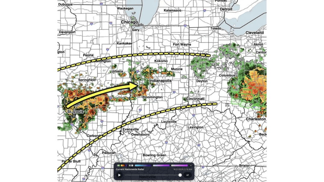
INDIANAPOLIS, INDIANA — As the first round of storms exits the region, additional coverage is beginning to fill in this AM. Heavy downpours from storms will lead to reduced visibilities and a localized flooding risk, so be careful on your morning commute, according to an AM Radar Update from BAMWeather, based on current radar as of 2:16 a.m. ET, September 21.
St. Louis and Springfield See the Heaviest Activity Already in Progress
If you’re in St. Louis or nearby Springfield, Illinois, radar already shows intense storm activity, marked by deep reds and oranges representing the heaviest rainfall, sitting directly over your area early this morning. An arrow on the radar graphic shows this activity tracking east toward Indianapolis, meaning if you’re heading out early in either city, expect reduced visibility and ponding on roadways from the start of your commute.
Indianapolis Directly in the Path as New Storms Push In
If you’re in Indianapolis, this morning’s radar shows a clear arrow pointing storm activity directly toward the city, with heavy downpours already developing over Bloomington to the south and pushing north. This is exactly the kind of setup forecasters are warning about: as the first round of storms clears out, new coverage is filling in right behind it, meaning your commute could go from clear to a heavy downpour with reduced visibility in a fairly short window this morning.
Kokomo and Muncie See Building Activity to the North
North of Indianapolis, Kokomo and Muncieboth show developing storm coverage on this morning’s radar as well. If you’re commuting through this part of central Indiana, be prepared for the same heavy rain and localized flooding concerns affecting Indianapolis to your south, since this activity appears to be part of the same broader system filling in behind the overnight’s earlier round.
Columbus and Southeastern Ohio Face Their Own Active Storm Cluster
Separate from the activity pushing into Indiana, Columbus, Ohio, shows a distinct and intense cluster of storms on radar this morning, with the heaviest returns extending toward Charleston, West Virginia. If you’re commuting anywhere across central or southeastern Ohio today, expect the same heavy downpour and flooding concerns, independent of what’s happening farther west near Indianapolis and St. Louis.
Yellow Dashed Lines Mark the Boundary of This Morning’s Active Corridor
Today’s radar graphic includes a yellow dashed boundary stretching from near Peoria across through Fort Wayne on the northern edge, and another running from near St. Louis through Louisville and toward Bristol on the southern edge. If you live or commute anywhere between these two lines, including Bloomington, Indianapolis, Daytonand Cincinnati, you’re within the corridor forecasters are highlighting as most likely to see this morning’s heaviest, most persistent rain.
Reduced Visibility Is a Real Hazard for Your Morning Drive
Forecasters specifically flagged reduced visibilities as a concern tied to this morning’s heavy downpours, not just flooding. Intense rainfall rates can cut visibility on highways dramatically in a matter of seconds, especially before sunrise when it’s already harder to see. If you’re driving through any of the areas currently showing heavy radar returns, slow down, increase your following distance and turn on your headlights even if it’s technically daylight by the time you head out.
Localized Flooding Risk Adds Extra Danger on Familiar Roads
Beyond visibility, forecasters warned of a localized flooding risk accompanying this morning’s storms. Roads that don’t normally flood can still pool water quickly when heavy rain falls in a short window, particularly in low-lying spots or areas with poor drainage. If your commute takes you through Indianapolis, St. Louis, Columbus or anywhere else within today’s active corridor, avoid driving through any standing water, since it’s often deeper and more dangerous than it appears from behind the wheel.
Bloomington, Dayton and Cincinnati Should Also Stay Alert
Communities along the southern edge of today’s active corridor, including Bloomington, Dayton and Cincinnati, should also expect the potential for heavy downpours as this morning’s coverage continues filling in. While the most intense activity as of this radar snapshot sits closer to St. Louis and Columbus, the broader corridor outlined by today’s forecast suggests these communities could see similar conditions as the morning progresses.
What This Second Round Means After Overnight’s First Storms
Forecasters were clear that this represents genuinely new storm coverage filling in behind the first round that’s already exited the region overnight, not just leftover rain from earlier storms. That distinction matters for your commute: even if you dealt with rain earlier in the night and thought the worst had passed, this second wave means the heavy downpour and flooding risk is starting fresh again this morning across the highlighted corridor.
How to Plan Your Commute Through This Morning’s Active Weather
If you’re anywhere within today’s outlined corridor, from St. Louis and Springfieldthrough Indianapolis, Kokomo, Muncie, Columbus and Charleston, build extra time into your morning commute and check radar before heading out the door. Given the combination of reduced visibility and localized flooding, this is a morning where a few extra minutes of caution behind the wheel is well worth it.


