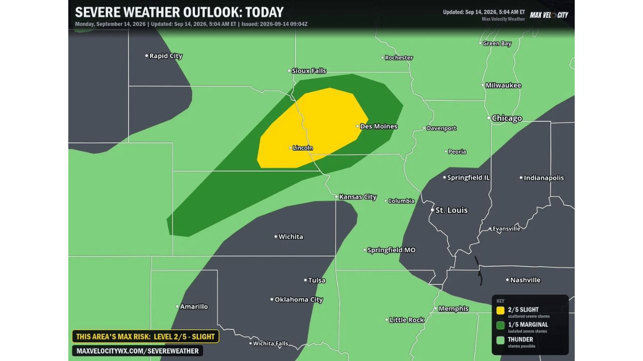
LINCOLN, NEB. — Significant severe weather remains possible across eastern Nebraskaand Iowa today, with Max Velocity Weatherwarning that a strong upper-level system is drawing a surge of very humid air into the region following this morning’s round of rain, setting the stage for rotating supercell thunderstorms late this afternoon and evening if the sun can break through.
The Key Question: Will Afternoon Sun Break Through Today’s Clouds?
Today’s forecast hinges on a specific question: whether the afternoon sun can break through the lingering cloud cover left behind by this morning’s rain and heat up the atmosphere enough to tap into the surge of humid air moving in. If that happens, forecasters say the resulting moisture and heat combination will help create a highly unstable environmentacross eastern Nebraska and Iowa.
Combined with favorable wind shear already in place, that kind of instability would support the development of rotating supercell thunderstorms later this afternoon and into the evening, giving today’s setup real teeth if the atmosphere manages to destabilize as forecasters anticipate.
Very Large Hail, Damaging Winds and Tornadoes All in Play
Forecasters specifically warn that any individual storm that manages to organize today will carry a significant risk for very large hail, localized damaging wind gusts, and tornadoes. That upgraded language, very large hail rather than simply large hail, signals meaningful confidence that today’s strongest cells could produce hail on the more dangerous end of the spectrum if supercells manage to develop as expected.
Communities across the highlighted corridor should prepare for the possibility of all three hazards from any storm that reaches its full potential today, rather than assuming only one type of severe weather is in play.
Even Clustering Storms Would Still Pose a Widespread Threat
Forecasters note that even if today’s storms quickly merge together into clusters rather than remaining discrete supercells, they will still pose a widespread threat for severe hail and damaging winds through the evening hours. That caveat matters because storm clusters can sometimes lose some of their tornado potential compared with isolated supercells, but today’s setup suggests the hail and wind threats would persist regardless of exactly how the storms organize.
Today’s outlook maintains a Slight Risk, Level 2 of 5, centered on the Lincoln and Des Moines corridor, with a surrounding Marginal Risk extending the lower-end threat across a broader stretch of the central Plains and Upper Midwest. With both the individual supercell scenario and the storm cluster scenario carrying real hazards, residents across eastern Nebraska and Iowa should stay weather aware through the afternoon and evening regardless of exactly how today’s storms ultimately take shape.


