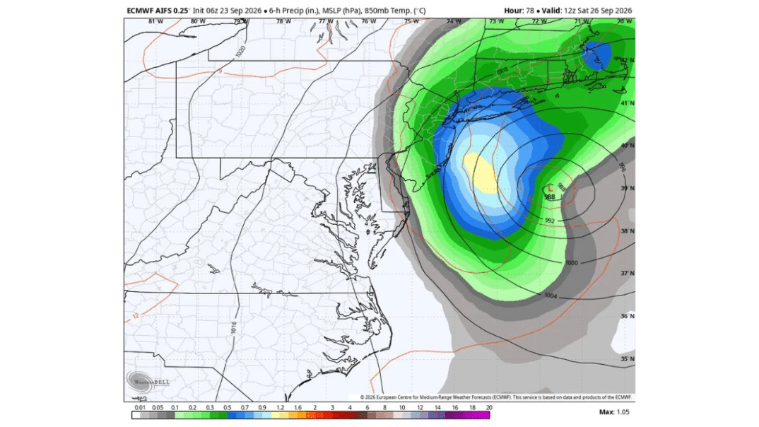
BOSTON, MASSACHUSETTS — Hybrid Howler this weekend? Not a classic Nor’easter. Not really a tropical system. A mix? Either way, the worst of the weather will likely be well north of the Maryland beaches, according to an ECMWF AIFS model run initialized 06Z September 23, 2026, valid 12Z Saturday, September 26. Some rain showers might even make it to Baltimore, but the New England coast will probably get hit hardest.

Boston and the New England Coast Face the Hardest Hit This Weekend
If you’re in Boston or anywhere along the New England coastline, this is the storm to watch closely heading into the weekend. Forecasters are direct that this stretch of coast will probably bear the brunt of the system, meaning residents here should plan for a genuinely disruptive Saturday rather than just a passing round of showers.
What a Hybrid Howler Actually Means
Forecasters are still working out exactly how to classify this system, calling it a hybrid because it doesn’t fit neatly into either box: not a classic Nor’easter, the kind that draws its energy purely from a cold-season temperature clash along the coast, and not really a tropical system either, despite carrying some tropical-like characteristics. That blended nature is exactly why confidence in the details remains lower than usual this far out, and why forecasters are urging residents to stay tuned rather than lock in firm weekend plans just yet.
Storm Deepens to 988 Millibars Just Off Long Island by Saturday
The model shows this system organizing into a tight, well-defined low, marked with a bold L, sitting just south of Long Island by Saturday afternoon, with a central pressure forecast at a striking 988 millibars. Pressure that low, tightly wrapped by closely packed isobars on the map, signals a genuinely powerful storm, the kind capable of producing strong winds and heavy rain across a wide swath of the coast even without a formal hurricane or Nor’easter label attached to it.
Heaviest Rainfall Band Targets Long Island Sound Into Southeastern New England
The model’s 6-hour precipitation shading shows the most intense rainfall, the darker blues and a small pocket of yellow indicating totals topping 1 inch in just a 6-hour window, concentrated in a band stretching from just south of Long Island up through Long Island Sound and into southeastern New England. If you’re anywhere along this corridor, expect this to be where the storm’s rain and wind combine most intensely as the low tracks through.
Cape Cod, Providence and Coastal Massachusetts Sit in the Bullseye
Within that heaviest band, Cape Cod, Providence and the broader coastal Massachusetts and Rhode Island shoreline sit right in the storm’s projected path. Residents across this stretch should treat Saturday as a day to have outdoor plans firmly flexible, since this is the zone forecasters specifically flagged as likely to get hit hardest by the entire system.
New York City and Long Island See Meaningful Rain and Wind Too
Just to the storm’s northwest, New York City and Long Island sit close enough to the developing low’s center that meaningful rain and gusty winds are likely here as well, even if the most extreme totals stay focused slightly farther east and north. If you’re anywhere across the NYC metro, this weekend’s system is still very much worth tracking, particularly given how close the storm’s center is forecast to pass.
Hartford and Inland Connecticut Also Fall Within the Wetter Zone
Moving inland, Hartford and the surrounding Connecticut River Valley sit within the broader green-shaded precipitation zone on the model, reflecting lighter but still real rainfall compared to the more intense coastal bands. If you’re in this part of New England, expect a wet Saturday, even if the wind and heaviest downpours stay concentrated closer to the immediate shoreline.
Maryland Beaches and the Delmarva Coast Stay Mostly on the Outer Edge
Farther south, the picture looks considerably calmer. The model shows Maryland’s beaches, including areas like Ocean City, sitting largely outside the shaded precipitation zone entirely, reflected in the mostly white, minimal-rainfall coloring covering the Delmarva Peninsula. If you had weekend beach plans on the Maryland or Delaware coast, this system looks unlikely to be the reason to cancel them.
Baltimore Could See Some Rain Showers, But Nothing Like Farther North
Forecasters specifically noted that some rain showers might even make it to Baltimore, acknowledging the storm’s broader moisture field could brush the northern Chesapeake region. If you’re in Baltimore, keep an umbrella handy just in case, but don’t expect anything approaching the intensity forecast for Boston or Cape Cod this weekend.
Washington DC Area Likely Spared the Worst
Based on the model’s current track, the Washington, D.C. area sits even farther removed from this storm’s core than Baltimore, well outside the heavier shading entirely. If you’re in the D.C. metro, this weekend’s system looks like it should have minimal direct impact on your area, with the storm’s energy staying focused hundreds of miles to the northeast.
Why Forecasters Are Still Saying Stay Tuned
Because this system defies easy classification, part Nor’easter, part something else entirely, and because its exact track and intensity remain subject to further refinement as the weekend approaches, forecasters are deliberately holding off on locking in every detail just yet. If you’re anywhere along the East Coast from Maryland up through New England, it’s worth checking back for updates as this Hybrid Howler continues taking shape heading into Saturday.
Stay with GordonRamsayClub.com for the latest updates.


