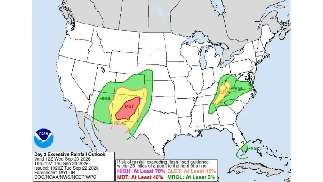
LUBBOCK, TEXAS — A Moderate Risk is in effect in the NWS Weather Prediction Center’s Day 2 Excessive Rainfall Outlook, valid 12Z Wednesday, September 23, through 12Z Thursday, September 24, 2026, issued at 1920Z Tuesday, September 22, by forecaster Taylor. The outlook centers its highest-confidence zone directly over the West Texas South Plains, with a much broader Slight and Marginal Risk corridor extending from eastern New Mexico through Texas, Oklahoma and Kansas, plus a separate zone stretching from Tennessee into the southern Appalachians and a smaller arc curving around Florida.
Lubbock, Midland and Odessa Sit at the Heart of the Moderate Risk
If you’re in Lubbock, Midland or Odessa, you’re positioned right inside tomorrow’s highest-category Moderate Risk zone, carrying at least a 40 percent chance of numerous flash floods within 25 miles of any point. This represents the most significant flooding concern anywhere in the country during this outlook period, meaning residents across the South Plains and Permian Basin should treat Wednesday into Thursday as an active weather situation rather than just a routine rain chance.
San Angelo and Big Spring Also Fall Within the Highest-Confidence Zone
The Moderate Risk shading extends south to include San Angelo and Big Spring, both sitting well within the reddest, highest-confidence portion of tomorrow’s outlook. If you’re anywhere across this stretch of West Texas, forecasters expect repeated rounds of heavy rain capable of quickly overwhelming drainage, so this is a day to keep a close eye on radar rather than assume any single round of rain will be the last.
Abilene, Wichita Falls and Amarillo Face a Broader Slight Risk
Surrounding the core Moderate Risk, a wider Slight Risk zone, carrying at least a 15 percent chance of scattered flash flooding, extends northeast to cover Abilene, Wichita Falls and reaches up toward Amarillo and the Texas Panhandle. If you’re in any of these communities, you’re not in tomorrow’s absolute highest-risk zone, but the same broader moisture plume responsible for the Lubbock threat extends into your area as well.
Roswell, Carlsbad and Southeastern New Mexico Sit in the Outer Marginal Zone
To the west, a Marginal Risk band, at least a 5 percent chance of isolated flash flooding, stretches into southeastern New Mexico, covering Roswell and Carlsbad. Residents across this part of New Mexico should stay weather aware Wednesday into Thursday, even though the most significant threat remains anchored farther east over the Texas South Plains.
Southwest Kansas and Western Oklahoma Also Fall Within the Outlined Corridor
On the northern end of the outlook, the Slight and Marginal Risk shading reaches up into southwestern Kansas and western Oklahoma, including areas around Wichita and Oklahoma City’s western suburbs. If you’re anywhere across this stretch of the southern Plains, keep an eye on updated forecasts, since the same system driving the Texas threat extends its moisture plume well into your region as well.
San Antonio and the Texas Hill Country Sit Near the Southern Edge
Toward the southern tip of the outlined corridor, the Slight Risk shading dips down near San Antonio and the Texas Hill Country, an area with a well-known history of dangerous flash flooding given its terrain. If you’re anywhere across this stretch, even a Marginal or Slight designation is worth taking seriously given how quickly water can rise in this region’s characteristic low-water crossings and narrow river valleys.
Knoxville, Asheville and Boone Face a Separate Southern Appalachians Threat
Well to the east, a second, entirely disconnected zone of Slight and Marginal Risk covers parts of eastern Tennessee, western North Carolina and southwestern Virginia, including Knoxville, Asheville and Boone. If you’re anywhere across this mountainous corridor, this represents a completely separate flooding concern from the Texas threat, tied to its own moisture and lift mechanisms working across the southern Appalachians.
Bristol and the Tri-Cities Region Also Fall Within the Eastern Zone
The same eastern corridor extends to include Bristol and the surrounding Tri-Cities area straddling the Tennessee-Virginia border. Residents across this stretch of the mountains should stay alert for locally heavy rain capable of producing rapid runoff, particularly given how steep terrain in this region can accelerate flash flooding even from moderate rainfall totals.
Tampa, Fort Myers and South Florida See a Thin Marginal Risk Arc
A separate, narrow Marginal Risk band curves along Florida’s Gulf coast and peninsula, reaching from around Tampa down through Fort Myers and toward Naples. If you’re anywhere along this stretch of Southwest Florida, isolated flash flooding remains possible during this period, even though this zone carries the lowest confidence category anywhere on tomorrow’s national outlook.
How the WPC’s Four-Tier Excessive Rainfall Risk Scale Works
Tomorrow’s outlook uses the Weather Prediction Center’s standard four-category scale, ranging from Marginal, at least a 5 percent chance, and Slight, at least 15 percent, up through Moderate, at least 40 percent, and, at the top, High, at least 70 percent. No areas were placed in the High Risk category, meaning the West Texas South Plains corridor around Lubbock and Midland represents the most significant flash flooding concern nationwide through 12Z Thursday.
Why West Texas Is Seeing Such a Concentrated Threat
The tightly wrapped, concentrated shape of the Moderate Risk zone over the South Plains points to a well-organized system tapping into deep moisture and repeatedly targeting the same stretch of communities rather than spreading rainfall thinly across a wider area. That kind of setup, storms training over the same towns rather than moving through and exiting quickly, is exactly what allows rainfall totals to climb fast enough to overwhelm West Texas’s typically dry terrain and limited drainage infrastructure.
What Residents Across Both Corridors Should Do
If you’re anywhere within the Moderate Risk zone, particularly Lubbock, Midland or Odessa, avoid driving through any flooded roadway and have a way to receive emergency alerts handy through Wednesday night into Thursday morning. If you’re in the separate eastern zone covering Knoxville, Asheville or Boone, or within the Florida arc near Tampa and Fort Myers, stay weather aware as well, since even a Marginal or Slight designation can produce dangerous, fast-rising water in vulnerable terrain.


