
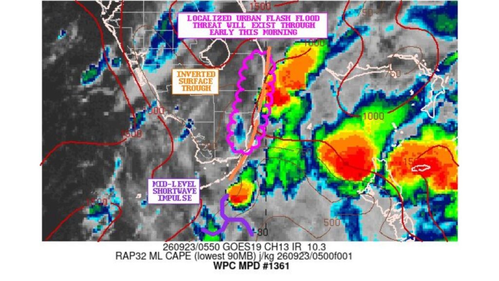
FORT LAUDERDALE, FLORIDA — The Weather Prediction Center issued Mesoscale Discussion 1361 covering southeast Florida, warning that a localized urban flash flood threat will exist through early this morning, according to the bulletin, tagged with the #flwx hashtag and based on GOES-19 satellite imagery and RAP32 model data valid 0550 UTC, September 23.
Southeast Florida Faces an Active Flash Flood Threat Right Now
If you’re anywhere across southeast Florida, this bulletin is specifically about your area right now, not a future forecast. The Weather Prediction Center flagged a localized urban flash flood threat as already unfolding through the early morning hours, meaning any heavy rain currently falling over city streets and low-lying neighborhoods could quickly translate into standing water on roadways before sunrise.
An Inverted Surface Trough Is Focusing Storms Along a Narrow Corridor
The satellite analysis highlights an inverted surface trough, marked by an orange line running roughly north to south through the heart of the outlined area. This kind of trough acts like a focusing lane for thunderstorm development, meaning the heaviest, most persistent rain tends to train repeatedly along this same narrow corridor rather than spreading evenly across the broader region, exactly the setup that drives up urban flash flood risk in a short window.
Mid-Level Shortwave Impulse Adds Extra Lift to the Southern Storms
Toward the southern end of the outlined zone, forecasters identified a mid-level shortwave impulse, an area of enhanced upper-atmosphere energy helping fuel the most intense storm cell visible on satellite. That impulse is contributing extra lift on top of the surface trough already in place, which is part of why the storms in this southern pocket appear so well-organized and intense on tonight’s infrared satellite loop.
The Magenta-Outlined Zone Marks Where the Threat Is Most Concentrated
On the satellite graphic, a magenta, scalloped outline traces the specific area where forecasters expect the localized urban flash flood threat to be most concentrated, running roughly along and just east of the inverted trough. If you’re inside or near this outlined zone, this is the stretch of southeast Florida where repeated rounds of heavy rain are considered most likely to overwhelm storm drains and city streets before the morning commute begins.
GOES-19 Infrared Imagery Shows Intense, Organized Storm Cells
The underlying GOES-19 Channel 13 infrared satellite image, captured at 0550 UTC, shows several pockets of intense convection, rendered in oranges and reds representing the coldest, highest cloud tops and therefore the strongest storms, scattered across the region. The most intense cell sits along the southern portion of the outlined corridor, directly beneath the labeled mid-level shortwave impulse, while additional strong cells appear farther east and offshore.
RAP Model Data Confirms Available Instability Fueling These Storms
Alongside the satellite imagery, the bulletin references RAP32 model data measuring mixed-layer CAPE, a standard measure of atmospheric instability, valid at 0500 UTC. Elevated instability values in this kind of overnight setup help explain why storms have been able to organize and intensify even during the pre-dawn hours, when thunderstorm activity often weakens without the boost of daytime heating.
Why Urban Areas Face a Heightened Flash Flood Risk
Forecasters specifically labeled this an urban flash flood threat because cities like those across southeast Florida have extensive impervious surfaces, roads, parking lots, rooftops, that prevent rainfall from soaking into the ground the way it would in open or rural terrain. When repeated rounds of heavy rain train along the same corridor, as this inverted surface trough is currently promoting, urban storm drains can become overwhelmed within a short period, leading to rapid, sometimes dangerous ponding on streets and underpasses.
What a Mesoscale Discussion Tells You That a Warning Doesn’t
A Mesoscale Discussion, or MPD, like this one is a specialized product the Weather Prediction Center issues to highlight an evolving, localized threat that may not yet meet the criteria for a Flash Flood Warning from local National Weather Service offices. Think of it as an early, detailed heads-up focused specifically on the meteorological setup, the trough, the shortwave, the instability, that’s actively fueling the danger, information often more technical than what you’d get in a standard warning but valuable for understanding exactly why this particular morning is higher risk than usual.
What Residents Across Southeast Florida Should Do Right Now
If you’re anywhere near the outlined corridor in southeast Florida early this morning, avoid driving through any street that already has standing water, since depth can be deceiving in the dark and a surprising amount of water can hide a stalled vehicle or open manhole. Keep a phone or weather radio nearby for any follow-up Flash Flood Warnings that local forecast offices may issue as this inverted surface trough and mid-level shortwave continue producing repeated rounds of intense rain through the early …
