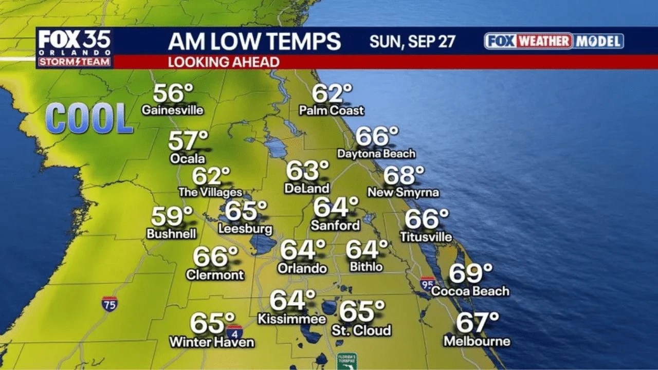
GAINESVILLE, FLORIDA — First fall front! Air temperatures Sunday morning, September 27, may dip into the upper 50s around Gainesville and Ocala, according to a Fox Weather Model forecast of AM low temperatures from the Fox 35 Orlando Storm Team. Average first temperature in the 50s each fall in Gainesville is October 4th, so this would be a hair earlier than normal. With the low humidity, everywhere will feel greatthough.
Gainesville Arrives at Its First 50s Reading a Week Ahead of Schedule
If you’re in Gainesville, Sunday morning’s low is forecast at just 56 degrees, landing you in the cool shaded zone on this weekend’s map. That’s notable because the average date for Gainesville’s first dip into the 50s each fall is October 4th, meaning this front is arriving roughly a week earlier than what residents typically experience heading into autumn.
Ocala Joins Gainesville in the Coolest Air of the Morning
Just south of Gainesville, Ocala is forecast for an equally crisp 57 degrees Sunday morning. Both cities anchor the coolest corner of today’s map, sitting within the same cool zone that forecasters specifically flagged as the area most likely to feel like a genuine taste of fall rather than just a marginally milder Florida morning.
Bushnell and The Villages See a Solid Cool Down Too
Continuing south, Bushnell is forecast for 59 degrees, while The Villages comes in slightly milder at 62 degrees. If you’re anywhere across this stretch of North Central Florida, expect a genuinely refreshing start to Sunday, even if you don’t quite match the standout numbers up in Gainesville and Ocala.
Orlando and Sanford Wake Up to Comfortable Mid-60s
If you’re in Orlando, Sunday’s low is forecast at 64 degrees, matching Bithlo at that same reading. Nearby Sanford comes in just slightly cooler at 64 degrees as well. While not quite as crisp as the 50s farther north, this still represents a meaningfully cooler start to the day than what Central Florida has grown used to through the summer months.
Clermont, Leesburg and Winter Haven Round Out a Comfortable Central Florida Morning
Across the western and southern reaches of Central Florida, Clermont is forecast for 66 degrees, with Leesburg at 65 degrees and Winter Haven matching that same 65 degrees. If you’re anywhere across this stretch, Sunday morning should feel genuinely pleasant compared to recent weeks, part of the broader cooldown working its way across the region.
Kissimmee and St. Cloud See Similar Comfortable Numbers
Just south of Orlando, Kissimmee is forecast for 64 degrees, with St. Cloud slightly higher at 65 degrees. Residents across this part of Osceola County should expect the same comfortable start to Sunday that’s spreading across the broader Orlando metro, even as temperatures trend a touch warmer than the standout lows up north.
DeLand and Sanford See Mid-60s as the Cool Air Reaches the Coast
Heading toward the east-central part of the state, DeLand is forecast for 63 degrees. This corridor sits right in the transition zone between the cooler interior and the milder immediate coastline, still benefiting from this weekend’s front even as temperatures trend slightly warmer than what’s forecast farther inland.
Palm Coast and Daytona Beach See a Milder Coastal Morning
Along the Atlantic coastline, Palm Coast is forecast for 62 degrees, with Daytona Beachslightly warmer at 66 degrees. If you’re anywhere along this stretch of coast, expect a noticeably milder morning compared to inland communities like Gainesville, a typical pattern given the moderating influence of nearby ocean water.
New Smyrna Beach and Titusville See the Coast’s Moderating Effect
Continuing down the coastline, New Smyrna Beach is forecast for 68 degrees, with Titusville cooler at 66 degrees. Both readings reflect how the immediate coast tends to lag behind inland areas when it comes to feeling the full effect of an incoming cool front, even as the broader push of drier air spreads across the entire region.
Cocoa Beach and Melbourne See the Warmest Readings on the Map
At the southern end of the Space Coast, Cocoa Beach is forecast for 69 degrees, the warmest reading anywhere on today’s map, with Melbourne close behind at 67 degrees. If you’re in either of these communities, Sunday morning will still feel like an improvement over recent conditions, just without the dramatic chill reaching Gainesvilleand Ocala farther inland.
Why Low Humidity Makes This Cooldown Feel Even Better
Beyond just the temperature numbers, forecasters emphasized that the accompanying low humidity is what will make this front feel especially great across the entire region, not just in the coolest spots up north. Even in areas only dipping into the mid-to-upper 60s, the drier air mass moving in behind this front means the morning will feel crisp and comfortable rather than muggy, a genuine shift from the sticky conditions that have defined much of the season so far.
What This Early Arrival Means for the Rest of Fall
With Gainesville’s typical first 50s reading not expected until October 4th, this weekend’s front arriving a week ahead of schedule is a promising early signal for anyone eager for autumn to take hold across North Central Florida. Whether this represents the start of a consistent pattern or just an early preview remains to be seen, but for residents anywhere from Gainesville and Ocala down through Orlando and out to the coast, Sunday morning offers a genuine, refreshing head start on the season.


