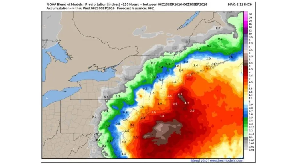
BOSTON, MASSACHUSETTS — The nor’easter that has been building along the East Coast is only now taking its true shape, with a new low pressure center forming east of Ocean City, Maryland on Friday morning. This low is expected to deepen, travel northwest then west, loop around and eventually produce heavy rain to go along with the strong winds. The latest NOAA Blend of Models shows rainfall totals of 4.3 to 4.7 inches across eastern Massachusetts, around 3.6 to 3.9 inches near Rhode Island and southeastern Massachusetts, and a maximum of 6.31 inches offshore through Wednesday morning, September 30.
Erosion and Overwash Came Before the Real Storm
One of the most surprising parts of this setup is that the beach erosion and overwash problems along the East Coast over the last two days had nothing to do with the nor’easter itself. Those impacts came from the strong wind pattern that set up ahead of the storm’s formation.
The actual storm, the low that forecasters are watching closely, only began forming off Ocean City this morning. That means the coastline has already taken a beating before the main system has even fully developed.
How the Storm Is Expected to Move
After forming off the Maryland coast, the low is forecast to strengthen and move northwest, then turn west, before looping around. This unusual track keeps the storm close to the coast for an extended period rather than quickly pulling out to sea.
That slow, looping motion is what raises the concern for heavy rain, since the same areas could see repeated bands of rain over multiple days.
Rain Starts in New England Friday, Reaches New Jersey Saturday
The rain could begin later Friday in New England, before working back toward New Jersey on Saturday. This backward, east-to-west spread of rain reflects the storm’s looping path.
The worst of the rainy weather is expected on Saturday and Sunday, as the low approaches the coast or briefly moves inland.
Eastern Massachusetts and Rhode Island Face the Highest Totals
The NOAA Blend of Models, covering the 120 hours from early September 25 through early September 30, shows the heaviest rain focused on eastern Massachusetts, where totals reach 4.3 to 4.7 inches.
Nearby areas around Rhode Island and southeastern Massachusetts, including the Cape Cod region, show 3.6 to 3.9 inches. Parts of central Massachusetts are forecast for around 2.6 inches, while the southern New Hampshire and Maine coast also shows pockets near 2.6 inches.
Long Island, Connecticut and New York City Rain Totals
Across the Long Island region, totals near 3.8 inches appear toward the eastern end, while the Long Island Sound and southern Connecticut shoreline show around 2.6 inches. Interior Connecticut is near 1.9 inches.
The New York City area is forecast for around 2.4 inches, with totals dropping off farther inland in the lower Hudson Valley, where amounts range near 1.5 inches.
New Jersey and Mid-Atlantic Rain Totals
In New Jersey, northern and coastal areas show 2.1 to 2.5 inches, while central New Jersey is near 1.5 to 1.6 inches. Southern New Jersey and the Delaware area show lighter amounts near 1.1 inches.
Farther west, rain totals drop sharply. Pennsylvania shows only about 0.1 to 0.9 inch, and western New York sees little to no rain.
Northern New England and Upstate New York See Less
In New Hampshire and Maine, interior areas are forecast for around 1 to 1.4 inches, while northern Vermont and far northern Maine see only 0.2 to 0.4 inch. Much of upstate New York stays on the lighter side, with totals generally under 1 inch.
Brief Break in Gusts Before Winds Return Tonight
As the pressure gradient loosens on Friday, residents may notice a temporary break in the higher wind gusts. This lull will not last long.
Once the low begins to influence the region Friday night, stronger winds are expected to return and continue through Monday, adding to the risk of downed trees, power outages and further coastal erosion.
How to Prepare for the Weekend
Use Friday’s lull to prepare. Clear gutters, downspouts and storm drains, and secure outdoor items before winds pick back up.
Charge phones and portable batteries, and keep flashlights ready. Avoid flooded roads, and coastal residents should move vehicles away from low-lying areas near the water.
