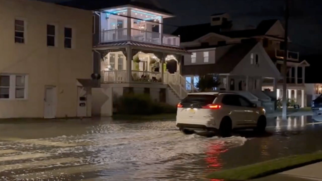
OCEAN CITY, NEW JERSEY — Floodwater was already pouring into neighborhood streets in Ocean City, New Jersey on Friday evening as the nor’easter closed in on the East Coast, and the worst is still ahead. Video from the barrier island showed flooded roads stretching curb to curb in front of homes as cars pushed through the water. After days of coastal erosion along the shoreline, the biggest impacts are expected Saturday into Sunday, with dangerous coastal flooding, heavy rain and strong winds threatening the Jersey Shore, New York City, Long Island, Connecticut, Rhode Island and Cape Cod.
 Floodwater Covers Ocean City Streets Before the Storm Peaks
Friday night footage from Ocean City showed water covering a residential street, reaching porch steps and front walkways while a vehicle crept through the flooded roadway.
This flooding arrived before the nor’easter’s peak, a warning sign for shore towns across Cape May County and Atlantic County, including Cape May, Wildwood, Sea Isle City, Margate and Atlantic City. Low-lying streets on these barrier islands are often the first to flood when onshore winds push ocean and bay water inland.
Jersey Shore Faces Repeated Rounds of High Tide Flooding
Farther north along the coast, Long Beach Island, Seaside Heights, Toms River and Point Pleasant are also at risk as the storm lingers. Lakewood Township and the Ocean County coast could see some of the heaviest rain in New Jersey, with model guidance showing totals above 3 inches in spots.
Because this storm is slow-moving and looping near the coast, communities may see multiple high tide cycles with flooding. Each round can push water farther inland, especially where dunes have already been weakened by days of erosion.
Long Island Faces the Highest Power Outage Risk
Long Island is expected to take one of the hardest hits from the wind. Communities across Nassau County and Suffolk County are in the highest risk zone for scattered power outages, with forecast guidance showing gusts of 55 mph or higher along the south shore and near 65 mph just offshore.
Gusty winds combined with trees still in full leaf could bring down tree limbs, entire trees and power lines. Coastal flooding is also a concern along the South Shore, including Long Beach, the Rockaways and Fire Island.
Cape Cod and Nantucket Brace for Gusts Near 70 MPH
The strongest winds of the entire storm are forecast around Cape Cod, Nantucket and Martha’s Vineyard, where gusts could reach 60 to near 70 mph. That level of wind can cause tree damage and widespread outages on the islands and outer Cape.
Major coastal impacts are highlighted around Boston Harbor and Cape Cod, with strong northeast winds driving water toward the shoreline and raising the risk of coastal flooding and beach erosion.
Rhode Island, Connecticut and Boston Face Heavy Rain
Along with the wind, southeast New England is facing a soaking rain. Boston and eastern Massachusetts could see 4 to 5 inches of rain, with 6 inches or more possible near the coast.
Providence, Newport and the Rhode Island coastline are expected to see gusts over 50 mph and 3 to 4 inches of rain. In Connecticut, New London, New Haven and Hartford are forecast for more than 3 inches, raising the risk of street flooding and flash flooding in the heaviest bands.
New York City Faces Flooding and Gusty Winds
New York City is forecast for around 2 inches of rain along with gusty winds through the weekend. Low-lying areas near the waterfront, including parts of Lower Manhattan, Staten Island, Brooklyn and Queens, should watch for coastal flooding during high tide.
Heavy rain can quickly overwhelm city drainage, leading to flooded underpasses, highways and subway entrances.
Massive Waves Pound the Atlantic Coast
Offshore, the storm is churning up enormous seas, with wave heights reaching around 23 feet south of New England and east of the Jersey Shore. Waves in the teens are forecast closer to the coastline from Rhode Island to New Jersey.
These waves will keep rip currents extremely dangerous and cause further beach erosion along already damaged shorelines. Stay off beaches, jetties and piers entirely.
Never Drive Through Flooded Streets
Some drivers attempted to move through Friday night’s floodwater in Ocean City, but this is extremely dangerous. Saltwater can destroy vehicles, and it is nearly impossible to judge water depth at night. Just a few inches of moving water can sweep a car away. Turn around, don’t drown.
How to Prepare Right Now
Move vehicles to higher ground before high tide. Secure outdoor furniture, trash cans and decorations. Charge phones and portable batteries, keep flashlights ready and follow local officials if they advise leaving flood-prone.
