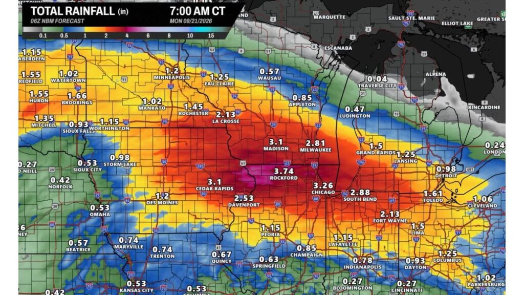
CHICAGO, ILLINOIS — If you have outdoor plans anywhere across the Upper Midwestthis weekend, timing and location will be everything as a heavy rainmaker pushes from west to east, according to a National Blend of Models, or NBM, forecast, run at 06Z and valid 7:00 a.m. CT Monday, September 21. While cities farther west like Minneapolis will see the rain wrap up completely by midnight tonight, the system will shift east just in time to wash out the weekend for southern Wisconsin and northern Illinois, with Rockford, Chicago and Madison sitting directly in the path of the heaviest rain.
Minneapolis Wraps Up by Midnight While the System Shifts East
If you’re in Minneapolis or the surrounding Twin Cities area, the good news is tonight’s rain is expected to wrap up completely by midnight, clearing the way for a mostly dry weekend on the western edge of this system. That’s not the case, however, for communities just a bit farther east: forecasters say the same system is shifting east just in time to wash out the weekend across southern Wisconsin and northern Illinois, meaning your outdoor plans this weekend may hinge entirely on which side of that shifting boundary you happen to live on.
Rockford, Chicago and Madison Sit in the Bullseye for 3 to Nearly 4 Inches
A concentrated corridor of heavy precipitation is forecast to set up directly over northern Illinois and southern Wisconsin, bringing widespread totals of 3 to nearly 4 inches to cities including Rockford, Chicago and Madison before the system finally clears out Sunday night. The single highest total on the forecast map belongs to Rockford at 3.74 inches, with Chicago close behind at 3.26 inches and Madison at 3.1 inches. If you’re anywhere in this corridor, this weekend is shaping up to be a washout, with the heaviest rain arriving right in the window most people typically reserve for outdoor plans.
Milwaukee, South Bend and Davenport Also Face a Solid Drenching
Just outside the absolute core of the heaviest rain, communities including Milwaukee, South Bend and Davenport will also get a solid drenching, with 2.5 to 3 inches on the way. Milwaukee is forecast for 2.81 inches, South Bend, Indiana, for 2.88 inches and Davenport, Iowa, for 2.53 inches. If you’re in one of these communities, expect a wetter-than-typical weekend even if you fall just short of the very highest totals centered on Rockford and Chicago.
La Crosse, Cedar Rapids and Fort Wayne Also See Meaningful Totals
Rounding out the corridor of heavier rain, La Crosse, Wisconsin, is forecast for 2.13 inches, matching Fort Wayne, Indiana, at the same 2.13 inches, while Cedar Rapids, Iowa, comes in higher at 3.1 inches, tying Madisonfor one of the highest totals outside the immediate Rockford-Chicago bullseye. If you’re anywhere along this broader stretch, from eastern Iowa through northern Illinois, southern Wisconsin and into northern Indiana, plan on a genuinely wet weekend rather than just scattered showers.
Localized Street Flooding and Ponding Threaten Poorly Drained Urban Areas
With so much water falling in such a short amount of time, forecasters are flagging localized ponding and street flooding as a real concern across urban areas and any spots that typically struggle with poor drainage. If you live in Chicago, Rockford, Madison or Milwaukee, this is worth taking seriously: even communities well accustomed to heavy rain can see standing water build up quickly on familiar streets and underpasses when 3 inches or more falls in a compressed window, so it’s worth having an alternate route in mind if your regular one has flooded before.
Des Moines, Peoria and Lansing See More Moderate Totals
Farther from the heaviest corridor, totals ease into a more moderate range. Des Moines, Iowa, is forecast for 1.2 inches, Peoria, Illinois, for 1.15 inches and Lansing, Michigan, for 1.25 inches, while Grand Rapids, Michigan, checks in a bit higher at 1.5 inches. If you’re in any of these communities, expect a noticeably wet weekend, just not the kind of extreme totals forecast for Rockford and Chicago.
Lightest Totals Stay West Across the Dakotas and South of I-70
The lightest totals on the forecast map stay concentrated across the Dakotas and toward the southern edge of the outlined system. Sioux City, Iowa, is forecast for just 0.53 inches, with Omaha, Kansas City and Columbia, Missouri, all coming in around 0.53 inches as well, while Indianapolis and Bloomington, Indiana, stay even lighter at just 0.27 inches each. If you’re in any of these communities, this particular system should pass through with far less impact than what’s expected farther north and east.
Plan Around Sunday Night for the System to Finally Clear
Across the hardest-hit corridor, forecasters say the heavy rain will finally clear out Sunday night, meaning if you’re in Rockford, Chicago, Madison, Milwaukee, South Bendor Davenport, your best bet for salvaging outdoor plans this weekend is to look toward the back end of the system rather than the front. With timing and location both playing such a critical role in how this weekend plays out, checking an updated forecast Saturday morning before finalizing any outdoor plans is well worth the extra few minutes, especially if you live in or near one of the communities facing the heaviest totals.


