CHICAGO, ILLINOIS — The early to mid October pattern looks to feature more frequent shots of colder air across the Eastern US, according to a Strong Cold Fronts outlook from BAMWeather. While the region has another warm up next week, forecasters are urging residents to keep a close eye on the potential for the coolest air of the season arriving behind stronger fronts around October 3rd through 5th and October 7th through 9th.
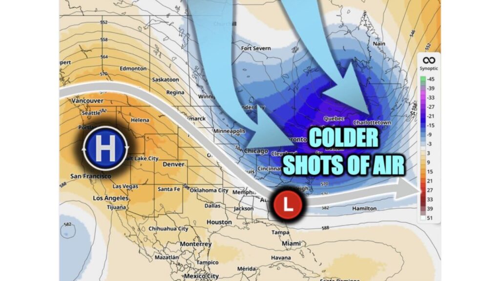
Chicago and Cleveland Sit Directly in the Path of the Colder Shots
If you’re in Chicago or Cleveland, you’re positioned right in the heart of the corridor labeled colder shots of air on this outlook’s jet stream graphic, with a strong flow of arrows tracing cold air plunging directly out of Canada and down through the Great Lakes. Residents across this stretch should treat the two flagged windows, October 3 to 5 and October 7 to 9, as the dates most likely to bring the first genuinely cold air of the entire fall season to your doorstep.
Minneapolis and the Upper Midwest Sit Closest to the Source of the Cold
Farther upstream, Minneapolis sits nearest to where this colder air originates as it drops south out of Saskatoon, Regina and Winnipeg in Canada. If you’re anywhere across the Upper Midwest, expect these two early-October cold shots to arrive first in your area before the same air mass continues pushing southeast toward the Great Lakesand eventually the East Coast.
Toronto and Quebec Also Fall Within the Colder Air Corridor
North of the border, Toronto and Quebec both sit within the same outlined corridor for colder shots of air, alongside Charlottetown farther east. If you’re anywhere across southern Ontario or Quebec, this same pattern affecting the northern US extends directly into your region as well, part of one continuous cold push tracing all the way from the Canadian Arctic down through the Great Lakes.
A Strong High Pressure Ridge Holds Firm Across the West Coast
While the Eastern US braces for colder shots, a very different story is unfolding out west. A surface high, marked with a bold H, sits parked over the Pacific Northwest and extends down through San Francisco, keeping this entire stretch of the West Coast under a milder, more stable pattern. If you’re in Seattle, Portland or Vancouver, this ridge means you’re largely insulated from the colder pattern taking shape farther east.
A Surface Low Near the Ohio Valley Helps Drive the Cold Push South
Driving the cold air’s push southeastward is a surface low, marked with a red L, positioned near the Ohio Valley close to Cincinnati. This low acts like a funnel, helping pull the colder air arriving from Canada down and around it before redirecting that chilly air farther southeast toward communities like Raleighand even toward Hamilton, out over the western Atlantic.
October 3 to 5 Marks the First Wave of Colder Air to Watch
The first of the two flagged windows, October 3rd through 5th, represents the initial pulse of this pattern change. Forecasters are specifically asking residents across the Eastern US to monitor this stretch closely, since it marks the leading edge of a broader shift away from the lingering warmth that’s dominated much of September and is set to make one more appearance with next week’s warm-up before this colder pattern takes hold.
October 7 to 9 Brings a Second, Potentially Stronger Cold Front
Just days later, a second window, October 7th through 9th, brings another round of the same colder air pattern. Back-to-back cold shots like this, arriving within roughly a week of each other, often signal a genuine pattern change rather than a single fleeting cool-down, meaning residents across Chicago, Clevelandand the broader Eastern US should prepare for this to be the stretch where fall finally starts to feel real.
Don’t Put Away the Fans Just Yet, Another Warm Up Comes First
Before any of this colder air arrives, forecasters note the region has another warm up coming next week. If you’re anywhere across the Eastern US, don’t be surprised if temperatures climb back up one more time before the pattern flips, a common late-September and early-October rhythm where warmth and the season’s first real cold shots trade places over a matter of days rather than weeks.
Memphis, Dallas and the South Stay Largely Outside the Cold Corridor
Farther south, communities including Memphis, Jackson and Dallas sit outside the main corridor forecasters have outlined for these colder shots of air. If you’re anywhere across this stretch of the South, expect this particular pattern to have a much smaller impact on your temperatures compared to what’s forecast for Chicago, Cleveland and points north, even as the broader Eastern UStrends cooler around these same dates.
Why 500 Millibar Height Contours Matter for This Forecast
The looping height contour lines on today’s map, ranging from 546 in the far north down through 588 across the South, trace the shape of the upper atmosphere’s flow, and the tight packing of these lines across the Great Lakesand Northeast is exactly what’s steering this colder air southeastward with such organization. When these contours dip sharply south like this, it’s a strong signal that genuinely cold, Canadian-sourced air is about to make a real push into the Lower 48 rather than just brushing the northern border.
Where to Find the Full October Outlook
Forecasters note there are more details on the full October Outlook available in the long-range tab on the BAM Weather App. If you’re anywhere across the Eastern US, particularly in the corridor stretching from Minneapolisthrough Chicago, Cleveland and toward the Northeast, this is worth checking as October 3 approaches, since these two windows represent the clearest signal yet for when the season’s coolest air is likely to finally arrive.


